


Over the next 25 years, India will add more people to its cities and towns than any other country.The World Urbanization Prospects 2025 (WUP25), released by the UN Department of Economic and Social Affairs, places India at the centre of the global urban transition.
Together with Nigeria, Pakistan, the Democratic Republic of Congo, Egypt, Bangladesh, and Ethiopia, India will account for more than half of the world’s growth in urban population between 2025 and 2050. Collectively, these seven countries are projected to add over 50 crores new urban residents during this period, with India alone contributing well over 20 crores. How India manages this scale of urban expansion will therefore have a disproportionate impact not only on national development outcomes, but on global sustainability and climate goals as well.
Methodological Shift
The World Urbanization Prospects 2025 introduces a major shift in how human settlements are defined, measured, and projected, providing the most spatially consistent and robust picture of settlement patterns worldwide.
Earlier,cities were defined using national statistical classifications reported by governments, which varied widely across countries and made global comparisons difficult. WUP25 addresses this challenge by integrating data generated by the Global Human Settlement Layer (GHSL)project of the European Union with the harmonised Degree of Urbanisation methodology. GHSL combines satellite imagery with census data to generate population density grids, while Degree of Urbanisation applies uniform population size and density thresholds to 1 km² grid cells, mapping entire national territories along an urban–rural continuum. This spatial, density-driven approach provides a common analytical language for understanding settlement patterns across different national contexts.
Second, WUP25 offers a more granular view of human settlements by clearly distinguishing between three settlement types: cities, towns, and rural areas.Under this new classification, cities are defined as dense urban centres with at least 50,000 inhabitants and a minimum density of 1,500 people per square kilometre. These areas have been the fastest-growing settlement type over recent decades and, as of 2025, are home to 45 per cent of the world’s 8.2 billion people—more than double their share in 1950.
Towns are identified as intermediate-density settlements, often functioning as transitional spaces between rural and urban areas. Defined as population clusters of at least 5,000 inhabitants with a density of at least 300 people per square kilometre, towns now account for 36 per cent of the global population, down from 40 per cent in 1950. Rural areas, characterised by lower densities, are home to just 19 per cent of the world’s population—a share that has halved over the same period.
Megacities matter, but smaller cities shape the urban future
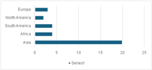
WUP25 reaffirms the continued rise of megacities, particularly in the Global South. The number of urban agglomerations with more thanone crore or 10 million inhabitants has quadrupled since 1975, reaching 33 in 2025. More than half of the Megacities are in Asia(see Figure – 1).
Figure 1: Most megacities are in Asia
Source: Developed by the author based on data sourced from the WUP 2025
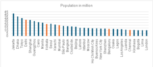
According to the revised methodology applied by the WUF 25, Jakarta has replaced Tokyo as the world’s most populous city, with nearly 42 million residents, followed by Dhaka with around 37 million.India is home to five megacities—Delhi, Kolkata, Mumbai, Bengaluru, and Chennai—with Delhi and Kolkata featuring among the world’s ten largest (see Figure2).
Figure 2 Megacities according to the Degree of Urbanization framework of the WUP 2025)\
 Source: Developed by the author based on data sourced from the WUP 2025
However, despite their scale and visibility, megacities account for only a relatively small share of the global urban population. The small and medium sized cities are thekey frontiersof global urbanisation. Between 1975 and 2025, the total number of cities worldwide more than doubled to around 12,000 and is projected to exceed 15,000 by 2050.
Urban land expansion outpacing population growth
One of the most troubling findings of WUP25 is the widening gap between population growth and land consumption. Between 1975 and 2025, the global extent of built-up land expanded almost twice as fast as the world’s population. As a result, average built-up land use per person increased from 44 to 63 square metres. This trend is especially pronounced in rural and peri-urban areas, where settlement expansion has often taken place in low-density, fragmented patterns.
What makes this dynamic particularly alarming is that land consumption has continued to rise even in cities and regions experiencing slow or negative population growth. This decoupling of demographic change from land expansion has far-reaching implications. The conversion of agricultural and ecological land undermines food security and ecosystem services, while dispersed urban forms increase infrastructure costs, energy use, and greenhouse gas emissions.
Policy implications for India
The WUP25 shows urbanisation is advancing faster, deeper, and more diffusely in India, than our official categories recognise. While Census 2011 placed India’s urbanisation level at 31.2 per cent, the Degree of Urbanisation methodology used in WUP25—suggests that about 40.3 per cent of India’s population already lives in cities in 2025. In addition, nearly 44 per cent of Indians currently live in towns or transitional areas, leaving barely 16 per cent in predominantly rural regions.
This contrast highlights the limitations of India’s national definition of “urban,” which remains among the most stringent in the world. Under the Census of India, a settlement is classified as urban only if it meets three criteria: a minimum population of 5,000; a population density of at least 400 persons per square kilometre; and at least 75 per cent of the male main working population engaged in non-agricultural activities. All other settlements are treated as “rural,” even though the term itself is not explicitly defined, obscuring the diversity of settlement forms that lie between these categories.
Further complications arise from ambiguities in managing rural–urban transitions. Settlements classified as “census towns” because they meet the census criteria for urbanisation often continue to be governed by rural institutions, resulting in weak planning controls and persistent infrastructure deficits. Between 2001 and 2011, the number of census towns increased sharply from 1,362 to 3,894. While the 74th Constitutional Amendment provides for recognising transitional areas as Nagar Panchayats, the responsibility for identifying and notifying such areas rests with states. In practice, wide variations in state-level procedures have led to uneven, delayed, and politically contingent urban transitions across the country.
This governance gap has direct consequences for land use. Peri-urban and transitional settlements frequently operate under lax zoning regulations, accelerating the conversion of fertile agricultural land into fragmented and inefficient urban sprawl. The Degree of Urbanisation-based insights from the WUP25therefore reinforce the need for a coherent rural–urban transition policy in India—one that establishes uniform standards for reclassification, strengthens metropolitan and regional planning, and enforces stricter land-use norms. Without redefining what counts as “urban” and tightening controls over land conversion, India risks undermining both food security and the sustainability of its rapidly urbanising landscape.
Note: This article was originally published in The Plurals under the title – Over next 25 years, India will add more people to its urban areas than any other country; UN report


